

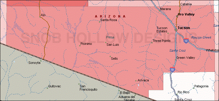
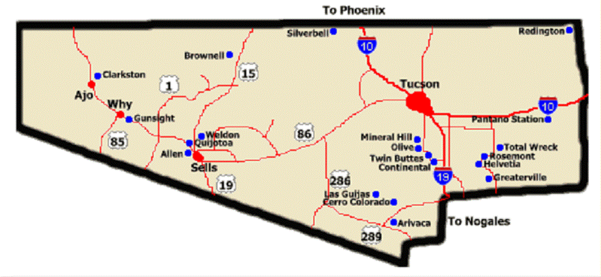
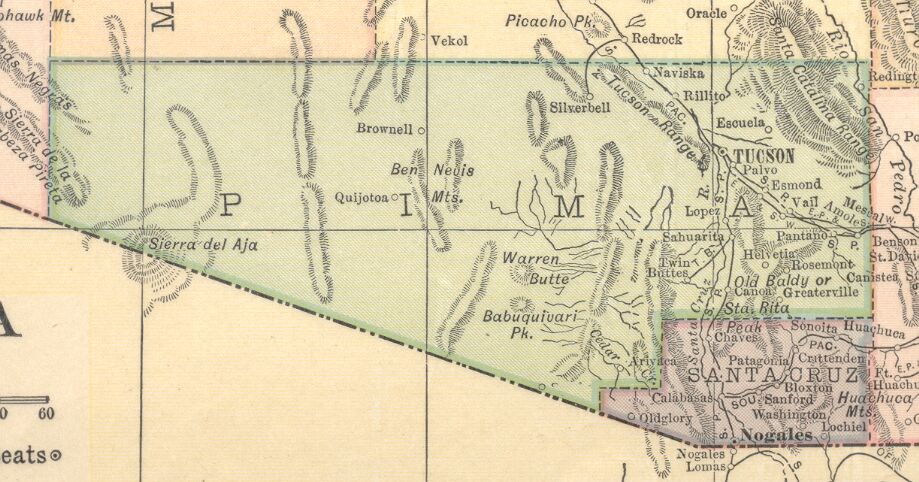
Pima County
AZGenWeb


1895
Courtesy of ghosttowns.com
1914

Ajo (pronounced ah-ho) is the Spanish word for garlic. The Spanish
may have named the place using the familiar word in place of the
similar-sounding O'odham word for paint (oʼoho). The Tohono O'odham people
obtained red paint pigments from the area.
Native Americans, Spaniards
and Americans have all extracted mineral wealth from Ajo's abundant ore
deposits. In the early nineteenth century, there was a Spanish mine nicknamed
"Old Bat Hole". It was later abandoned due to Indian raids. The first Anglo in
Ajo, Tom Childs, on the way to the silver mines near Magdalena de Kino, Sonora,
arrived in 1847 and found the deserted mine complete with a 60-foot shaft,
mesquite ladders, and rawhide buckets. High-grade native copper made Ajo the
first copper mine in Arizona. Soon the Arizona Mining & Trading company, formed
by Peter M. Brady, a friend of Childs, worked the rich surface ores, shipping
loads around Cape Horn for smelting in Swansea, Wales, in the mid 1880s. The
mine closed when a ship sank off the coast of Patagonia. Long supply lines and
the lack of water discouraged large mining companies.
With the advent of
new recovery methods for low-grade ore, Ajo boomed. In 1911, Col. John Campbell
Greenway, a Rough Rider and star Yale athlete, bought the New Cornelia mine from
John Boddie. He became general manager of the Calumet and the Arizona mining
company and expanded it on a grand scale. In 1921, Phelps Dodge, the nation's
largest copper company, bought New Cornelia and the mine became the New Cornelia
Branch of Phelps Dodge, managed by Michael Curley. For several decades more than
1,000 men worked for Phelps Dodge in the open pit mine. The mine closed in 1985,
following a bitter strike and a depressed copper market.
The Gunsight Mine was located on 25 Nov 1878, by a man
named Myers and three others. THe mine was named because of its location near a
mountain with a striking resemblance to a gun sight with the "barrel" of the gun
being formed by a ridge. The sunsight portion of this formation looks like a
flat whisky bottle seen sideways. The first name fot eh mining community in this
area was Allen or Allen City, named for John Brackett Allen (born 1818 in Maine,
died 13 Jun 1899) the merchant for the camp. He first came to Arizona in 1857
and returned in 1862 with the California Column. Thereafter he settled near
Yuma, had a store at Maricopa Wells, and finally moved to Tucson. Allen seems to
have followed the mining camps in establishing his stores. His name crops up
time and again in the history of mining communities of Pima County. In his later
years he lived in Florence.
Extracted 28 Jul 2017 from Arizona Place
Names, page 267.
In 1693 Fr. Kino passed through this area on a missionizing journey during which he made brief stops. With his lieutenant, Juan Mateo Manje, he stopped at a place they called El Altar, where the river disappeared in the sand. The Altar River has its source near the Mexican boundary and flows south, whereas the Altar Valley heads near the same place, but extends north.
The origin of the name Arivaca remains obscure, but many explanations have been advanced for it. Mrs. Mary B. Aguirre, who arrived in Arizona c.1869, said it was a Papago Indian name, hijovajilla ("son of the great valley"), and the great valley being the wide "avri" valley. On the other hand, Isaac D. Smith in his manuscript history sadi the name was an Indian one meaning "rotten ground". Kirk Bryan advanced the hypothesis that the name was a Mexican corruption of the Indian Alivapk, in which vapk indicated "reeds", plus ali, meaning "little". Riggs says Ali-Bac means "where little people dig holes," the "people" being the way Papago refer to animals. Whatever its origin, the name is very old, appearing as the Indian village of Aribac (or Arivaca) on a map dated 1773. As a direct result of the Pima Indian Revolt in 1751, it was deserted. Mines near it continued to be worked by the Spanish until 1767. In 1812 Agustin Ortiz petitioned for two farming lots of the Aribac Ranch. His petition having been granted, the land was surveyed and auctioned October 10, 1812. Ortiz was the successful bidder at $799.59. He never received title to the land, but his sons obtained the title in 1833 by providing their father had paid for the land. The place was deserted in 1835. Tomas sold his share to his brother Ignacio on June 7, 1856, for $500.00. In December, 1856, Charles Debrille Poston noted in his journal that he had bought the place from Tomas and Ignacio Ortiz for $10,000. The reduction works for the Heintzelman (Cerro Colorado) Mine were then erected at Arivaca. Later still, the Court of Private Land Claims disallowed the Arivaca Land Grant, today a thriving settlement."
The Avra Valley is the northern portion of the Altar Valley. The southern portion of this valley is sometimes referred to as the Arivaca Valley.
In 1854 Charles Debrille Poston and Herman Ehrenberg visited Arizona to investigate
mining possibilities. During their visit they spent some time near Tubac where they
found old abandoned mines worth reworking. Poston thereupon went to the East
Coast in 1855 and by March 1856 had organized the Sonora Exploring and Mining
Company. The company bought the old Arivaca Ranch and secured title to mines in
the Santa Rita Mountains east of Tubac. Included in their purchases was Cerro
Colorado where there were twenty-nine silver mines. THe name Cerro Colorado was
used by Mexicans to describe the conical red hill, a landmark in the area.
The most famous of the mines in the Cerro Colorado group was the Heintzelman
Mine, named for Samuel P. Heintzelman, president of the mining company. The
superintendent was John Poston, brother of Charles Poston. Despite the richness
of the mines, many difficulties were encountered and the mines failed to pay
off. Chief among the difficulties was trouble with Apache Indians, whose
depredations forced the mine owners to abandon their holdings following the
withdrawal of federal troops in the summer of 1861. In addition there was
trouble with the native Mexican workers, some of whom murdered John Poston.
Soon after the end of the Civil War, miners began returning to Arizona and
by 1870 there were fifty-eight people living at Cerro Colorado. In 1880
reduction works were constructed at Arivaca. The mines remained active for many
years, but today are deserted and in ruins.
Extracted 28 Jul 2017 from
Arizona Place Names, page 261.
On a map made by Captain
Overman, the entire valley from Tucson to the pass between the end of the
Rincons bears the name of Cienegos de los Pinos. This same designation is
carried on another map as Cienegas de los Pinos. The only change on GLO 1869 is
to the name Cienegas de las Pimas. The name Cienaga first appears on the GLO
1876. In 1883 when the railroad came through and established a station, the name
Pantano appears close to the old and vanished location of Cienaga.
The
name of the stage station extablished in 1858 by the Butterfield Overland Stage
line at this point was descriptive; it was sometimes called Cienaga Springs.
Several visitors to this place have noted the fact that it had sweet and cool
water. The adobe buildings fo the stage station were abandoned when Butterfield
dropped its stage line through southern Arizona. IT did not take long for the
buildings to fall into ruins, caused in part by a devastating fire. The First
California Voluntters camped here on June 21, 1862, noting that there had been a
fire some time between the closing of the route and that date.
Following
the Civil War, the Cienega again became a stage station, frequently subjected to
Apache attack. Here in 1867 W. A. "Shotgun" Smith and three companions were
attacked by Indiana. All but Smith were killed. He used his shotgun to such
advantage that he killed or wounded about eight Apaches. In 1870 when the point
was called Miller's Station, the mail carrier and a man named Scott Young were
butchered Apache style and the station again destroyed.
With the coming
of the railroad, Cienaga ceased to exist for the simple reason that the railroad
tracks passed over the foundation of the old stage station buildings.
Extracted 28 Jul 2017 from Arizona Place Names , pages 262-263.
When the New Cornelia Copper Company built a company-owned town,
opposition developed to living in the new location. Cam Clark proceeded to lay
out a townsite on some mining claims near the reduction works of the mining
company. THis place was referred to as Clarkston or Clarkstown. The copper
company refused to sell water to the residents of Clarkstown, who retaliated by
deepening a test shaft for a new mining location to get water. Their community
was more popular in 1916 and 1917 than the mining company town. Clarkstown then
had about one thousand residents, but the place went into a decline towards the
end of 1917.
Meanwhile the residents of Clarkstown applied for a post
office. Because of the great popularity of President Woodrow Wilson, they
desired to call their post office either Wilson or Woodrow, but both names were
ruled out by the Post Office Department. The residents got around this by
reversing the name Woodrow and came up with the name Rowood. One month after the
townspeople got their name for the post office, it was changed to Samclark, but
this name did not stick.
In 1931 Clarkstown was almost completely
destroyed by fire. Following htis, what was left of the community was moved to
Ajo. The post office survived for many years, the Rowood post office being moved
to Gibson nearby but retaining the name Rowood.
Extracted 28 Jul 2017
from Arizona Place Names , page 263.
The Continental Rubber Company in 1914 purchased part of the old Canoa Land Grant.
The company planned to grow guayule, which yields guayule rubber. A railroad
siding, post office, and headquarters for the operation were established at
Continental.
Extracted 28 Jul 2017 from Arizona Place Names , page 263.
When this point on the railroad was first
established it was called Esmond, but the reason for so doing is not known. In
1912 the name was changed to Cruz by dropping Santa from the name of the Santa
Cruz River. The name was changed to save time in telegraphy.
Extracted 28
Jul 2017 from Arizona Place Names, page 264.
Today’s Diamond Bell Ranch was once part of the vast Robles
Ranch, which was established in 1882 by Bernabe Robles (b.1857 in Baviacora,
Sonora, Mexico, d.ca 1945 in Tucson). Robles Ranch was once one of Arizona’s
largest cattle ranching operations: the 1.5 million acre “El Rancho Viejo”
stretched from Florence to the Superstition Mountains to the Mexican border from
1889 to 1918. Following severe drought and overstocking of livestock in late
1800s and early 20th century, the ranch began to be sold off. By 1949, Robles
Ranch was reduced to only 50 square miles, and by the mid-1980s, the ranch was
sold and broken into small parcels.
From the 1950s to the 1970s, the area
of the current Diamond Bell Ranch was known as the O-Bar-J Ranch. In 1979, the
Chilton family bought the ranch, and purchased an additional 4,000 acres to the
north around 1990. The northern part of the ranch called Diamond Bell Ranch, was
sold after failed efforts in the late 1960s and 1970s to develop the entire
ranch into a high- density subdivision. Diamond Bell Ranch became part of the
Chilton Ranch and Cattle Company and managed by the Chilton family as a cattle
ranch from 1979 to the present.
Dowling was a mining camp which also had an adobe custom house. It was named for Pat Dowling, a miner sho had a smelter here. By 1915 the place was abandoned.
The Emery family lived at this location, hence the name. P.O. ext.
September 21, 1928. Camilla M. Emery, p.m. Name changed to Butland, January 2,
1931. Rescinded, December 24, 1931. Discont. September 30, 1952.
Extracted 28 Jul 2017 from Arizona Place Names, page 265.
Fresnal was a Papago village visited by Pumpelly in 1860.
Emerson Oliver Stratton bought land c. 1885 about where the current day Flowing Wells district is located. Stratton planned to use the land for farming. The name was discriptiove of the quantity of water available.
Matthew Ellsworth Gibson, Sr., laid out a townsite on a group of mining claims north of those held by the New Cornelia Copper Company. Gibson and his family arrived in the vicinity in 1912. When Clarkstown was nearly burned out in 1931, the Rowood post office was moved to Gibson. The current name of the place is North Ajo.
Located along "Renegade's Route." Post office established 03 Jan 1879, Thomas Steele as Postmaster. P.O. was discontinued 30 Jun 1946.
The Laguna Stage Station on
the road to Asacaton in 1869 had a population of about eighty-five pioneers.
Distinguished guests were met here by the elite of Tucson who escorted them to
the Old Pueblo.
The fact that the stage station lay nine miles from
Tucson led to its being called Nine Mile Waterhole.
Located in Organ Pipe Cactus National Monument, on
international border, the small village lies on sixty-seven acres owned by
Charles Luke of Phoenix.
Extracted 28 Jul 2017 from Arizona Place Names,
page 271.
Marana has a long and rich history with more than
4,200 years of continuous human occupation in Marana and the surrounding middle
Santa Cruz Valley. Long before the coming of the Spanish Conquistadors and
missionaries in the 17th Century, the area was inhabited by the Hohokam people
who developed extensive canal systems and used waters from the Santa Cruz River
to irrigate crops.
The first European to visit the Marana area was a
Jesuit Priest, Father Eusebio Francisco Kino in 1694. In 1775, Juan Bautista de
Anza, Captain of the Presidio of Tubac led an expedition north along the Santa
Cruz River to found the city of San Francisco. With the area under the
jurisdiction of the United States in 1854, prospectors seeking mineral riches
intensified their efforts in the region. Gold was not discovered in abundance,
but by 1865, high-grade copper ore was being shipped from mines in the Silver
Bell Mountains.
Rail transportation came in 1881 and signaled a major
change in the area. It gave Marana its first identification as a specific place
by appearing on Southern Pacific Railroad maps in 1890. “Maraña” is a Spanish
word meaning a jungle, a tangle or a thicket and was chosen as an appropriate
name by the railroad workers as they hacked their way through the dense brush.
With the early establishment of mining and ranching, it was not until after WWI
that Marana became primarily an agricultural center, producing mainly cotton,
but also wheat, barley, alfalfa and pecans.
During World War II, the
impact of the rising importance of military power came quickly to Marana. The
Marana airfield (1942-1945) was the largest pilot-training center in the world
during WWII, training some 10,000 flyers, and five Titan missile sites were
later located in the area as part of a complex of ballistic missile
installations built around Tucson.
In March 1977, the Town incorporated
about 10 square miles and in August the 1,500 townspeople elected their first
town council. In early 1979, the town began to grow through an aggressive annexation
policy and is nearly 120 square miles with an estimated population of 33,000.
In 1920 Mineral Hill was a mining camp with a store and a post office on the route then commonly used from Tucson to Nogales. When the new road was built, Mineral Hill lost its minor importance.
The Oury brothers were prominent citizens in Tucson. All three
brothers were born at Abingdon, Virginia. The oldest was William S. (b. 13 Aug
1816). William took part in teh Mexican War and then went to California during
the Gold Rush. He came to Arizona in 1857 as the first agent for the Butterfield
Overland Stage. It was William who was a leader in the Camp Grant Massacre.
The second brother was named Marcus (b. 03 Feb 1821, d. 1865). His name may
have been Marius. He was killed by Apaches near Tucson, which accounts in part
for the hatred his brother William bore toward Apaches.
The third brother
was named Granville (b. 12 Mar 1825). He, like William, went to California in
1849. Grant, as he was called, came to Arizona in 1859. By 1860 he was Chief
Justice of the Supreme Court for the Provisional Government of Arizona. He
resigned the same year. During his lifetime he attained eminence as a lawyer and
a politician. It was he who in 1857 led the party that went to the relief of the
Crabb expedition.
Extracted 28 Jul 2017 from Arizona Place Names, page 274.
Olive was the post office for Olive Camp, a mining
community occupied by mine employes and the James Kilroy Brown family, and owned
by S. B. Conway of Boston in the 1880's. The camp was named for Olive Stephenson
(b. July 24, 1858), who married Brown. The Browns arrived in Arizona on December
24, 1879, at Casa Grande. They moved to Tucson in July 1880, and later to Olive
Camp. The mine was sold in the late 1880's.
Extracted 28 Jul 2017 from
Arizona Place Names, page 273.
The area of Oro Valley has
been inhabited discontinuously for nearly two thousand years by various groups
of people. The Native American Hohokam tribe lived in the Honeybee Village
located in the foothills of the Tortolita Mountains on Oro Valley's far north
side around 500 AD. Hohokam artifacts continue to be discovered in the Honeybee
Village that the Hohokam inhabited continuously for nearly 700 years, and
studied by archaeologists around the globe.
Early in the 16th century,
Native American tribes known as the Apache arrived in the southern Arizona area,
including Oro Valley. These tribes inhabited the region only a few decades prior
to the arrival of the Spanish Conquistadors, including Francisco Coronado. The
Spanish established forts in the area, including the Presidio at Tucson (1775)
beginning in the late 16th century.
Beginning in the 19th century,
Americans increasingly settled in the Arizona Territory, following the
Mexican-American War and the subsequent Gadsden Purchase including Southern
Arizona. George Pusch, a German immigrant, settled in the area of Oro Valley in
1874, establishing a cattle ranch. This ranch was unique because it utilized a
steam pump to provide water, eventually popularizing Pusch's property as the
Steam Pump Ranch on the Cañada del Oro. The steam pump was one of only two in
the Arizona Territory.
Pusch's ranch provided respite for settlers and
travelers entering and leaving the Tucson area. Pusch Ridge is named in honor of
George Pusch.
Ranching in the area continued to flourish as greater
numbers of Americans settled in the Arizona Territory. Large ranching families
in the Oro Valley area included the Romeros and the Rooneys.
Gold rushers
into the American West also were attracted to southern Arizona, where gold was
said to be in abundance in and around the Santa Catalina Mountains north of
Tucson. Fueled by the legend of the lost Iron Door Gold Mine in the mountains,
those in search of gold trekked through the Oro Valley area focusing their
attention along the Cañada del Oro washbed.
After World War II, the
Tucson area experienced dramatic population growth, impacting Oro Valley as
well. In the early 1950s the Oro Valley Country Club opened at the base of Pusch
Ridge, affirming the area's future as an affluent community. Although one tract
housing development was built in the area in the early 1950s, the majority of
homes in the Oro Valley area were built by individual land owners on large lots
in a low density residential style.
Pisinemo is a summer rancheria of the Papago Indians. Most of its houses are substantially built of adobe.
In 1863 there were about 385 Indian living at this
location. Apparently mining went on in this region as early as 1774 when it is
reported that ores were shipped to Baja California, for reduction. Mining work
of great importance here in 1879 with the discovery of copper, and in 1883, when
even better deposits were uncovered. Quijotoa surged forward as a mining center.
A townsite known as Quijotoa City was laid out under the ownership of Charles H.
Beckwith and George L. Rognon. Other townsites also sprang into existence. By 1885
the ores were exhausted and Quijotoa went into a decline. It has now almost
completely vanished.
Extracted 28 Jul 2017 from Arizona Place Names, page 276.
The Redfield brothers settled approximately six miles
south on the San Pedro River from where the present community of Redington is
now located. The earlier community was located by Henry and Lem Redfield in 1875
and they established a post office at their ranch. Since the Post Office
Department would not accept the name Redfield for the office, the brothers
coined the name Redington.
In the next several years, outlaws used the
vicinity of Redington when hiding out form the law. In 1883 some of these
bandits robbed a stage and committed a murder a mile and a half north of the old
Riverside stage station. Tracked to the Redfield ranch, Joe Tuttle was found
with much of the loot; he was with Lem Redfield. Both men and Frank Carpenter,
who had also been caught, were imprisoned at Florence where Tuttle confessed
that he and Charlie Hensley committed the crime and that Redfield was to be cut
in on the loot for hiding the money. Redfield denied the accusation, His brother
Henry, deciding that Lem's life was in danger, went to Florence with seven men
and a Deputy United States Marshal to take Lem to Phoenix for safety's sake.
Aroused, the citizens of Florence immediately lynched Lem Redfield and Joe
Tuttle. THere has been much doubt that Redfield had any part in the crime for
which he was lynched.
Extracted 28 Jul 2017 from Arizona Place Names,
page 277.
Rillito appears on the railroad on GLO 1903. There
was a community called Rieletto which had thirty-two people according to the
census of 1870, but it is not known whether this has any connection with the
location on the railroad. The name of Rillito was changed to Langhorne after the
family by that name which resided there. IT retained this name fo four years.
Extracted 28 Jul 2017 from Arizona Place Names, page 278.
If you listen to the old-timers, they'll tell you
that Three Points shouldn't even be called Three Points. They insist the correct
name is Robles Junction, after Bernabe Robles. In 1864, at the age of 7, Robles
crossed with his mother into Southern Arizona on donkeys, in search of a new
home and new opportunities. Eventually, the family opened a market in Tucson,
and Robles started a ranch in what was then a way-out desert west of town.
Robles worked hard, acquired large tracts of land and got rich--an American
success story. But oral and written accounts of early settlers tell of a man
given to hard-core business tactics, and they include the charge that Robles
loaned money to strapped ranchers, then took their land when they couldn't repay
it. His methods reportedly made him few friends, and if history leaves
footprints on the land--a sort of genetic trail for those who come later--then
the trail from Three Points leads back to hardscrabble, tough-as-bad-jerky
Robles.
The Historic Robles Ranch what was once the headquarters of one
of the largest ranches in Arizona is located at Robles Junction (Three Points).
The old headquarters buildings are north of the highway just as you come to
Three Points. They sit among large old eucalyptus trees, with barns and corrals
off to the side. The ranch house was established in 1882, as a stage stop, by
Bernabe' Robles, who operated a stage line from Tucson to the mining town of
Quijotoa on what later became the Papago and then the Tohono O'odham
Reservation. Bernabe' Robles was born in Babiacara, Sonora in 1857. In 1864,
when he was 7 years old, he moved with his family to Tucson. He established
himself as a businessman early on by delivering bread for a local bakery. Prior
to establishing the Robles Ranch, which he called Rancho Viejo, Senor Robles was
engaged in the saloon business, the general merchandise business, and
established a stage line to Quijotoa.
The stage stop was established in
the 1880s as a water and rest stop for the horses at a point on the road to
Quijotoa where the road to Altar, Sonora branched off to the south. A well was
dug and several adobe buildings constructed at what is now the old headquarters.
The stage, ranching complex, and the settlement that grew up around it soon
became known as Robles Junction. By 1885, the copper, silver, and gold views
were exhausted at Quijotoa with a consequent downtown in freighting and stage
business. Robles then focused his efforts on building as extensive cattle
operation. At the height of the enterprise, the ranch comprised over one million
acres reaching from Florence, Arizona on the north to the Mexican border over
100 miles to the south, making it one of the largest ranches in Southern Arizona
at the time.
An early name for Rosemont was
McCleary Camp, after the locator of the claims.
Rosemont was located in
the southeastern part of the Helvetia district and may possibly have had some
claims in the late 1870's and early 1880's. They were owned by William McCleary,
who in 1894 sold them to L. J. Rose. The Rosemont Mining and Smelting Company in
turn was sold in 1896 to the Lewisohn brothers of New York CIty. THe smelters
were closed down at Rosemont in 1907 during an industrial depression.
Extracted 28 Jul 2017 from Arizona Place Names, page 278.
Sahuarita was founded in 1911 and incorporated in 1994.
The first known
human inhabitants of the Sahuarita region were the Hohokam people, which may be
the ancestors of the modern day Tohono O'odham nation. The Hohokam were known
for their highly innovative and extensive use of irrigation. The Hohokam were a
very peaceful people, they had extensive trade routes extending to mesoamerica,
and showed many cultural influences from their southern neighbors.
The
Sobaipuri were possibly related to the Hohokam, and occupied the Southern
portion of the Santa Cruz, with the Pima to their North and South. While
Coronado passed just East of Sahuarita in 1521, it wasn't until Eusebio Kino's
1691 journey along the Santa Cruz River that he met the leaders of the Sobaipuri
people. Kino was a true champion of the indigenous Indians, opposing forced
labor in mines by Spanish overseers. Kino would later go on to found the Mission
San Xavier del Bac in 1699, just north of Sahuarita. In 1775, Fransico Garcés
would follow the same path, laying the groundwork for the founding of Tucson.
In 1775, after building a series of missions in the region, the Spanish
established a colony in Tucson, just north of Sahuarita, effectively placing the
region under Spanish control. After the Mexican War of Independence in 1821, the
region came under Mexican control.
In 1854, following the Gadsden
Purchase, Sahuarita would become a part of the Territory of Arizona, in the
United States of America. In the same year, Andrew B. Gray would travel the
region on behalf of the Texas Western Railroad, in order to run a preliminary
survey of the region. Meanwhile, the Native American peoples of the region were
being pushed onto each other's land through American expansionism. In 1857, the
Sobaipuri, who had acted as a buffer between the hostile Spaniards to the South
and Apache to the North, finally collapsed under the pressure and vacated the
area, generally moving Westward to Papago territory. In 1867, Fort Crittenden
was created between Sonoita and Patagonia in order to support the establishment
of European settlements in the Santa Cruz Valley. In 1874, the San Xavier
reservation was created, presently called the Tohono O'odham Reservation, and
Native Americans were forcibly relocated to the reservation.
An 1870 map
of Arizona shows an "Indian Village" just north of Sahuarita. The earliest known
reference to the town can be found on a German map from 1875, which labels the
town "Sahuarito". The first known US map to list the town came in 1879, by the
US Department of Interior, calling the town "Saurita". The Saurita town name
would continue to be found on successive maps of 1880 and 1890. Finally, a 1925
map of "Auto Trails" (e.g. roadways) of Arizona and New Mexico lists
"Continental" instead of Sahuarita. The roadway at the time was an "improved
road", one step inferior to a "paved road", laying the route to what today is
called the Old Nogales Highway.
In 1879 Sahuarita Ranch was created by
James Kilroy Brown. Brown choose the name Sahuarita due to the preponderance of
saguaros in the area. The ranch was used as a staging area between Tucson,
Arivaca, and Quijotoa. A small community developed in the area named Sahuarito,
while the railroad laid tracks through the area (which remain to this day) and
established a station and post office. Although originally surveyed by the Texas
Western Railroad, the route would soon be run by the Southern Pacific Railroad
up until the late 20th century. Brown sold his ranch in 1886 which caused the
region to stagnate for three decades.
During this time, the hub of
Sahuarita commerce was at the intersection of Sahuarita Road and Nogales
Highway, in the form of the One Stop Market and Sahuarita Bar and Grill. These
130-year-old buildings remain intact, but they are scheduled to be demolished
for a road expansion: "While some have said the 1 Stop and the shuttered
Sahuarita Bar on the north side of Sahuarita Road were long-time fixtures that
might deserve historic recognition, the longest-serving council member, Charles
Oldham, and the council member who lives closest, Marty Moreno, both said the
convenience store should make way for badly needed road improvements. Oldham
said, “It’s in the way”."
The Continental Farm of Sahuarita plays a
central role in town history. In 1915, worried about the possibility of a German
blockade of rubber imports, Bernard Baruch, Joseph Kennedy and J.P. Morgan
founded the farm along the Santa Cruz River with hopes of growing guayule:
plants that provide rubber. The project was abandoned after the end of World War
I, and in 1922, was sold to Queen Wilhelmina of the Netherlands. The Queen
rented the land to cotton farmers, in what would be the primary crop for the
following four decades. In 1948, R. Keith Walden relocated the Farmers
Investment Co. (FICO) from California to Arizona, buying the Continental Farm
lands from the Queen. In 1965, over fears of a fall in demand for cotton
resulting from the advent of synthetic fibers, Walden switched his crop to
pecans. Today, the FICO pecan orchard is the largest in the world, with over
6,000 acres (24 km2) and 106,000 trees.
San Xavier del Bac, Arizona, is a beautifully preserved gem of the late Baroque style of New Spain. Completed in 1797, it stands in the San Xavier District of Tohono O'odham Nation, about twelve miles south of Tucson, Arizona. Alone of the Sonoran Desert missions, San Xavier is still served by Franciscans, and still serves the Native community for which it was built.
The present Sasabe took shape as a private development under hard-working Carlos
Escalante, nephew of Don Fernando Serrano, Sr. Don Fernando escaped from Mexico during
the 1910 Madero Revolution and surveyed six hundred acres where he settled in 1913
as a cattleman. Here, on what was known as the old Reveil Ranch, settled Carlos
Escalante in 1916. In the same year a new port of entry was established with the
erection of three tents. This was necessary because of the lack of water at the
old Sasabe. Young Escalante labored to erect quarters for residents from old
Sasabe, who were moving into his little private village, which he named San
Fernando in honor of his uncle. The name was changed later because of confusion
in mails with the post office at San Fernando, California. Mr. and Mrs.
Escalante have created by their efforts a town with in 1957 had a population of
sixty-five, a school, a Catholic church, and on its outskirts the U. S. Customs
House which was built in 1935-36.
Extracted 28 Jul 2017 from Arizona
Place Names, page 281.
It was in this canyon that Henry
Lazard (b. France, 30 Oct 1831; d. 11 Mar 1895) with his partner, Sam Hughes,
maintained a sawmill. Lazard arrived in Arizona in 1858 and by 1860 was a
partner with Hughes. In 1869 the men erected a sawmill in the Santa Rita
Mountains, employing twenty-four teams to haul lumber. The mill burned in 1870,
but Lazard bought another.
Lazard was something of a character. A small,
excitable man, he was totally deaf and apparently believing everyone else was
too, he customarily talked in a voice which could be heard two blocks away.
Lazard lived extremely well, importing French wine by the barrel for the sake of
his health.
Also known as Dowdle Canyon, after David Dowdle, who had a
ranch nearby. This name appeared on the Roskruge map of 1893.
Extracted
28 Jul 2017 from Arizona Place Names, page 281.
On GLO 1909 this
location shows as Artesa at the north end of the Artesa Mountains. Thereafter
that name disappears. However, c. 1920 Kirk Bryan noted that a new town of
Artesa was located a mile from Indian Oasis. It may be, however, that when
Joseph Meneger dug the first well the older settlement shifted somewhat to
Indian Oasis, so called because it was the only place where there was permanent
water.
In 1918 the name of the post office was changed to Sells, so named
for Cato Sells, who was then commissioner of Indian Affairs. Inasmuch as the
post office was located on federal land, it took an act of Congress to change
the name. The location was becoming important following the construction of
government buildings as headquarters for the Papago Indian Reservation.
Extracted 28 Jul 2017 from Arizona Place Names, page 281.
South Tucson is a city in Pima County, Arizona, United States and an enclave of the much larger city of Tucson. South Tucson is known for being heavily influenced by Hispanic, and especially Mexican, culture; restaurants and shops which sell traditional Mexican foods and other goods can be found throughout the city. According to 2005 Census Bureau estimates, the population of the city is 5,562.
In 1882 William Reed and
a man named Carter homesteaded here, but failed to prove up the land. They
called the place Carter's Camp. Somewhat later Frederick E. A. Kimball was
instrumental in establishing a summer colony with a descriptive name.
Extracted 28 Jul 2017 from Arizona Place Names, page 283.
The name Tanque Verde dates back to the 1860's. In 1858 William
Oury bought cattle from a drover headed for California. Later Oury bought in
four hundred blooded Kentucky cattle and transferred his herd to Tanque Verde
where he had a ranch. Two or more fairly large water holes containing green
algae are the source of the name. The holes are at the base of Tanque Verde
Ridge, a northwestern extension of the Rincon Mountains.
The present-day
small community of Tanque Verde is not the same as that which appears on GLO
1892 adjacent to Fort Lowell. The post office was at the earlier location.
Extracted 28 Jul 2017 from Arizona Place Names, pages 283-284.
Three Points sits 45 miles from Mexico, at the crossroads of Highway 86 (which runs east to west between Tucson and Ajo) and Highway 286 (which runs south to the border at Sasabe and is called simply The Corridor). Robles Junction is an unincorporated community in Pima County, Arizona, United States. Robles Junction is located at the intersection of Arizona State Route 86 and Arizona State Route 286 southwest of Tucson. Route 286 traverses the center of the slightly northeast-trending Altar Valley; Sasabe is at the southern terminus, and Robles Junction is at the northern. The Altar Valley ends at the area of Robles Junction, with two other valleys converging from the northwest. The Aguirre Valley is west and the Avra Valley is east.
John T. (Jerry) Dillon came to Arizona
from New Mexico in 1876. In 1877 he discovered the first silver mines in the
Empire Mountains and located the Total Wreck mining claims. When he found this
location, he had no mining notices of ownership with him and went to obtain
some. He was asked to give a name for the place, whereupon he described it as
being a "big ledge, but a total wreck, the whole hillside being covered with big
boulders of quartz which have broken off the ledge and rolled down." From that
came the name Total Wreck. Dillon, a cowboy, sold the property to the Empire
Mining and Development Company and it was in turn sold for taxes to Vail and
Gates c. 1883. A fairly large mining community developed at this location. The
mine has been worked form time to time since 1907.
Extracted 28 Jul 2017
from Arizona Place Names, page 284.
Tucson was probably first
visited by Paleo-Indians, known to have been in southern Arizona by about 12,000
years ago. Recent archaeological excavations near the Santa Cruz River have
located a village site dating from 4,000 years ago. The floodplain of the Santa
Cruz River was extensively farmed during the Early Agricultural period, circa
1200 BC to AD 150. These people constructed irrigation canals and grew corn,
beans, and other crops while gathering wild plants and hunting animals. The
Early Ceramic period occupation of Tucson saw the first extensive use of pottery
vessels for cooking and storage. The groups designated by archaeologists as the
Hohokam lived in the area from AD 600-1450 and are known for their red-on-brown
pottery.
Jesuit missionary Eusebio Francisco Kino visited the Santa Cruz
River valley in 1692, and founded the Mission San Xavier del Bac about 7 miles
(12 km) upstream from the site of the settlement of Tucson in 1700. The Spanish
established a presidio (fort) on August 20 1775 and the town came to be called
"Tucson." Tucson became a part of Mexico after Mexico gained independence from
Spain in 1821. Following the Gadsden purchase in 1853, Tucson became a part of
the United States of America, although the American military did not formally
take over control of the community until March 1856. From August 1861, until
mid-1862, Tucson was the capital of the Confederate Arizona Territory. Until
1863, Tucson and all of Arizona was part of New Mexico Territory. From 1867 to
1879, Tucson was the capital of Arizona Territory. The University of Arizona,
located in Tucson, was founded in 1885.
By 1900, 7,531 people lived in
the city. At about this time, the US Veterans Administration had begun
construction on the present Veterans Hospital. Many veterans who had been gassed
in World War I and were in need of respiratory therapy began coming to Tucson
after the war, due to the clean dry air. The population increased gradually to
13,913 in 1910, 20,292 in 1920, and 36,818 in 1940. In 2006 the population of
Pima County, in which Tucson is located, passed one million while the City of
Tucson's population was 535,000.
During the territorial and early
statehood periods, Tucson was Arizona's largest city and commercial area,
whereas Phoenix was the seat of state government and agriculture. The
establishment of Tucson Municipal Airport increased its prominence. By the
1920s-30s, Phoenix outgrew Tucson and has continued to expand. Tucson has still
been growing but at a slower pace.
Walter Vail, a cattleman with large holdings, gave the railroad the right of way through his property in 1880, and the railroad point from which supplies were freighted to mines was named for him.
The Weldon Mine was highly successful and at one time there were several thousand people living at Weldon. Weldon vanished and in its place is San Antone, a location used by a few Papago families as a winter rancheria.
Copyright © 1996- The USGenWeb® Project, AZGenWeb, Pima County

This page was last updated
07/12/2026