

Pima County
AZGenWeb

Pima County was the one of four original Arizona Counties created 10 Nov 1864 by the 1st Arizona Territorial Legislature.
"This Territory shall be divided into four counties, to be bounded and named as hereinafter provided.
"First, the County of Pima, shall be bounded as follows: On the east by 109th meridian of longitude, on the line of the Territory of New Mexico, on the north by the middle of the main branch of the Gila river, on the west by the line of 113 degrees 20 minutes west longitude, and on the south by the Sonora line. The seat of justice whereof is hereby established at Tucson, and the County Commissioners are hereby empowered to establish precincts in said county.
"Second, the County of Yuma, ...
"Third, the County of Mohave, ...
"Fourth, the County of Yavapai, ...."
Pima County lies at the northern range of the Sonoran
Desert, and is comprised of mountain ranges, river valleys, and cactus forests.
Recent archaeological digs along the Santa Cruz River near Tucson suggest that
this area is one of the oldest continuously inhabited areas of the United
States, with irrigation canals that may be the oldest in North America. Native
Americans have continuously inhabited this region from prehistoric times to the
present. The Tohono O'odham reservation in Pima County is the second largest
reservation in the nation.
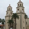
The Spanish
Father Kino founded the
Mission of San Xavier del Bac in 1697 and it is still in use today. It is
considered by many to be the most beautiful of all the Kino Missions.
In
1775, Juan Bautista de Anza and his colonizing expedition, traveled northward
along the Santa Cruz River on their way to San Francisco. Along the way, they
passed through a Tohono O’odham settlement they called Tuquison.
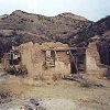
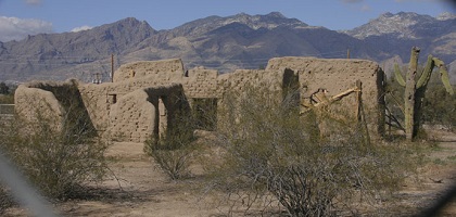
Earlier
that year, on August 20, 1775, the Spanish authorities founded the Presidio of
San Agustín del Tucson, on the banks of the Santa Cruz River. The Royal Presidio
de San Augustin del Tucson was completed by 1781, and it remained the
northern-most outpost of Mexico until the arrival of American soldiers in 1856.
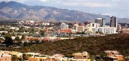
From a population of 395 in 1820, Tucson has grown to be the second largest city
in Arizona. It has always served as the Pima County seat and was the Arizona
Territorial capital from 1867 to 1877. Tucson is home to the University of
Arizona and many historical, ecological, and cultural attractions.
The
United States
Pima County, the second largest of the four original
Arizona counties, was created by the 1st Arizona Territorial Legislature in 1864
with land acquired through the Gadsden Purchase from Mexico in 1853;
approximately all of southern Arizona was acquired from Mexico by the Gadsden
Purchase. European settlement of the region goes back to the arrival in the
1690s of the Spanish.
The original county consisted of all of Arizona
Territory east of latitude 113° 20' and south of the Gila River. Soon
thereafter, the counties of Cochise, Graham and Santa Cruz were carved from the
original Pima County.
About the middle of the 18th century, silver and
gold were discovered in the region and prospectors from Mexico entered the area
in droves. The latter part of the century saw expansion of mining and ranching
in Pima County and an increase in population, despite the threat of attack from
roaming bands of Apaches.
Although greatly reduced from its original
size, Pima County still covers 9,184 square miles. It ranges in elevation from
1,200 feet to the 9,185-foot peak of Mount Lemmon. The San Xavier, Pascua Yaqui
and Tohono O'odham reservations together account for ownership of 42.1 percent
of county land. The state of Arizona owns 14.9 percent; the U.S. Forest Service
and Bureau of Land Management, 12.1 percent; other public lands, 17.1 percent;
and individual or corporate ownership, 13.8 percent. Pima County has two
Enterprise Zones, one in South Tucson and portions of Tucson and the other in an
unincorporated portion of the county just southwest of Tucson. --Source unknown.
The story of the development and growth of Tucson from an old desert pueblo to
what has been very aptly termed "The livest-big-little city in the Southwest," is a
story worthy of a master's telling. From the establishment of the San Xavier Del
Bac Mission in 1687 to the coming of the Southern Pacific Railroad in 1878, it
was a typical frontier town. Unprotected from the ravages of the Apaches and
other tribes until the establishment of Fort Lowell in 1866, it offered but
small inducements to the settler, but upon the completion of the railroad came
first the miner and prospector, then the shop-keeper, and finally, hearing in
some way of the wonderful healing qualities of the climate, the health seeker
and tourist. The miner discovered an immense resource, and capital built great
smelters, until Tucson became the center of the world's richest copper mining
section. The tourist and health-seeker came to be the resident, built homes,
hotels and business blocks, and today we have a modern up-to-date city of more
than 20,000; a city of homes and schools and churches, a city of business
houses, progressive and growing.
These forces have given the city a
splendid foundation, and made possible its wonderful growth into the city of
today from a town of little more than 1,000 in 1900. But 1912 has seen the
development of another great resource, sufficient water to irrigate thousands of
acres of arable land tributary to the city, and the birth of a new era. Tucson
will soon have an agricultural back country capable of supporting a great
population and making it a power in the development of the Southwest. And all
because one man dreamed of such a possibility, believed in his dream and fought
for it. To his belief and work is due the coming of the Tucson Farms Company,
and its development work the clearing, irrigating and placing under cultivation
of more than 6,000 acres in the Santa Cruz Valley. This is but the beginning of
an extensive agricultural development, for other companies are now in the field
doing a similar work.
Commercially, Tucson is located on the main trunk
line of the Southern Pacific, at the end of a division, and is the present
western terminus of the El Paso & Southwestern System. It is also the northern
terminus of the great railway system now pushing down the West Coast of Mexico
under the direction of the Southern Pacific, connecting Tucson with the Mexican
seaports of Guaymas and Mazatlan, and destined to reach Guadalajara, and thence
by the National line to the City of Mexico.
Politically, it is the
official seat of Pima County, a county rich in mines and in grazing and
agricultural lands, the area of which is equal to that of Massachusetts and
Rhode Island combined.
The strength of the city is in the network of
railroads reaching east and west and south. Here is the division headquarters of
the Southern Pacific's Sunset Route and its repair shops and army of employees,
and also the general offices of the Arizona Eastern Railway and of the Southern
Pacific's Mexican West Coast Lines.
The short, direct line from Tucson to
Nogales places Tucson in a strategic position, making it the gateway to that
vast fertile region lying along the West Coast of Mexico, which is now being
opened to settlement by Americans by the construction of the Southern Pacific's
road down through Sonora and across the broad valleys of the Yaqui and Mayo
Rivers.
In addition to this the El Paso & Southwestern has now built into
Tucson from Benson, connecting Tucson with the mining towns of Bisbee and
Douglas and the prosperous commercial city of El Paso, Texas. It is headed
westward, and will connect Phoenix and Yuma with Tucson, while it has projected
a spur to the rich mineral fields in the Santa Catalina Mountains north of the
city, and a road from Sasco west of Tucson, to Port Lobos on the Gulf of
California. This would make a fertile country in the extreme southwest tributary
to this city and add another and shorter route to the Mexican Coast, the one
actually in operation being the Southern Pacific line to Guaymas and Mazatlan.
Mining assets include not only the mines of Pima and Santa Cruz Counties,
but largely of Pinal and Cochise counties and of part of New Mexico and the
Mexican state of Sonora. This district is perhaps the richest copper mining
district in the world. The opening of the plant of the Pioneer Smelting Company
early in 1912 has caused a resumption of operations in the Helvetia, Mineral
Hill and Twin Buttes districts and the development of other properties, and has
brought $40,000 per month net into Pima County and Tucson. A great variety of
copper ore is found in the county, and gold, silver, zinc, tungsten, lead and
galena are produced here. The trade of the city in mining machinery and supplies
of many kinds extends over a large area on both sides of the international
boundary.
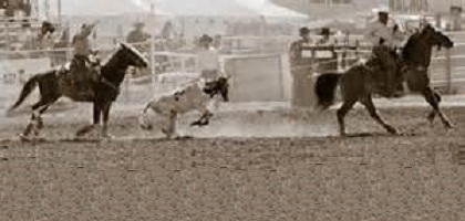
The Cattle Industry is one of the large resources of the
county, and the value of range cattle shipped from Tucson in a single year has
exceeded $900,000.
The county has always been famous for the abundance
and quality of its beef cattle. This is due to the great area of grazing lands
and to the nutritious and highly flavored wild grasses of the mountain slopes,
which impart a sweetness and flavor to beef unattainable by fattening in the
stall or even upon alfalfa.
Tucson is the chief educational center of the
state, owing to the location here of the University of Arizona, with its score
of professors and teachers, and of the United States Agricultural Experiment
Station, with chemical laboratories and facilities for specializing in several
important agricultural studies. The University of Arizona is situated a mile
from the heart of the city. Through its Agricultural and Mining Departments,
this institution has a most vital and intimate connection with the Southwest,
and particularly with Arizona.
The public schools, of which there are
five, and the high school, were built at a cost of over $300,000 and are among
the best looking structures in the city. The schools are so well distributed
that scarcely a home in the city is more than a five-minute walk from one of
them. The new high school building has fifteen recitation rooms, with
laboratories for physiography, chemistry and physics and a fine assembly hall
with a seating capacity of more than eight hundred.
The city has several
private and denominational institutions.
The Methodist School for Mexican
Girls, conducted by the Home Missionary Society of the Methodist Episcopal
Church, cares for 48 girls in a $16,000 home. A training school for Pima and
Papago Indians, conducted by the Women's Board of Missions of the Presbyterian
Church has an enrollment of over a hundred and fifty. The institution has a one
hundred and sixty-acre farm near the city and $50,000 has been spent on its
buildings.
More than 125 pupils are instructed at the Papago Indian
School, maintained at the San Xavier Mission by the Sisters of St. Joseph. The
work in behalf of the Papagoes is supplemented by the United States Government,
which has a $10,000 school house and dormitory.
In the city itself the
Catholic church is active in the educational field, maintaining an excellent
parochial school with an enrollment of nearly 400, and St. Joseph's Orphanage,
the home of 40 children. A most important work is also done by the St. Joseph's
Academy, a boarding school for girls and young ladies. This institution has an
enrollment of 200 and offers a very thorough course of study, not only in the
elementary branches but also in high school study, music, art, etc. Their full
course prepares for regular College work.
The climate of Tucson,
especially in the winter months, is acknowledged to be the best on the American
continent. In the past three years there have been but ten days in which the sun
did not shine in this city. This is the great feature of the region the amount
of sunshine and it is in arid regions that the sun attains its greatest
vivifying influence. The germicidal power of sunshine is well known, and here
the chemical activity of its rays is not lost in clouds or fogs, but exerts its
full force. There is no other portion of the United States that will compare
favorably with that in and about Tucson for the relief of pulmonary affections.
That is the opinion of eminent physicians and scientific climatologists, and the
basis of this opinion is the maximum of sunshine, the clearness of the
atmosphere and the rapid radiation which brings a tonic and refreshing coolness
to the night. And the summer is dry. The experts of the Experiment Station say
that to get the sensible summer temperature here it is necessary to subtract
fifteen to thirty degrees from the maximum. That is to say, the dryness of the
air makes Tucson that much cooler than the East under corresponding
temperatures.
The average rainfall for forty-one years at Tucson is 11.66
inches. The average for the past ten years has been 11.78, the greatest
precipitation occurring during July and August, with December a good third.
The summer storms are short, uncertain, refreshing. The air parts with its
humidity rapidly, and the clear, tonic, dry atmosphere returns quickly.
Travelers say this atmosphere of Southern Arizona has the same bracing and
exhilarating qualities as the air of the Sahara, and that it is drier than any
part of the valley of the Nile north of the Cataract.
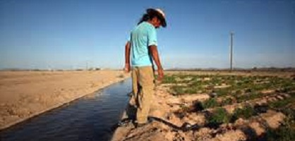
Water for the city
comes from wells located in the valley four miles distant. The capacity of the
present water works has been outgrown, and is now being enlarged, a bond issue
providing $125,000 to cover the cost. In a small way windmills are made use of
for irrigation, but power pumps are most relied on, water being obtained at from
10 to 150 feet.
The economic aspect of pumping for irrigation has been
well threshed out, the conclusion being that while not so cheap or convenient as
ditch supplies from rivers, the productivity of the land in this climate and the
increased market value of the products, make the slightly increased cost of
pumping economical, while there are some important advantages over ditch
irrigation. Well supplies are continuous and fairly uniform throughout the year,
and water is available when it is most needed.
The Tucson Gas, Electric
Light and Power Company supplies power for manufacturing as well as gas and
electricity for domestic use. Several miles of line have also been thrown out
into the surrounding country to supply pumping plants for irrigation.
Tucson is essentially a city of homes. The residential streets and districts
attract attention for their beauty and adaptation of the architecture to the
climate, and because of the gardens and trees.
On the social and
religious side Tucson is the equal of any Eastern city of the same size. There
are twelve churches: two Methodist, two Baptist and two Presbyterian, as well as
Catholic, Episcopal, Congregational, Christian, Christian Science, Lutheran and
Jewish.
Practically all the fraternal organizations are represented, and
there are several clubs, four of which occupy buildings of their own. The Old
Pueblo Club building was recently completed at a cost of $60,000, and the Eagles
have just finished splendid clubrooms in their own building. There are
organizations for women also, including the Woman's Club, the Collegiate Club
and the Music Club.
THE CONSOLIDATED NATIONAL BANK, Tucson, is the oldest and largest bank in the
city, and in its history is interwoven a portion of the history of many of the
ablest financiers in the Southwest. The first bank in Tucson was The Pima County
Bank, organized in the early seventies, which subsequently became known as The
First National Bank of Tucson. The Bank of D. Henderson was later organized, and
in 1887, The First National Bank of Tucson, having surrendered its charter some
years previous and become The Bank of Tucson, was merged with the bank of D.
Henderson, and thus was formed the Consolidated Bank of Tucson. M. P. Freeman,
who had been cashier of The Bank of D. Henderson, was instrumental in this
consolidation and became cashier of the newly formed bank, while Mr. B. M.
Jacobs, organizer of The Pima County Bank, and until recently president of The
Arizona National Bank, was the first president, and Mr. D. Henderson, first vice
president. Shortly afterwards a national charter was obtained and the name
changed to The Consolidated National Bank, by which it is now known. In 1898,
owing to ill health, Mr. Freeman retired from The Consolidated National Bank,
and the following year, having fully recuperated, was one of the prime movers in
the establishment of the Santa Cruz Valley Bank. In 1895 he again became
associated with The Consolidated National Bank as its vice president. At that
time H. E. Lacy was president, and H. B. Tenney, cashier. On Mr. Lacy's
retirement from the presidency, Mr. Freeman was elected to this position, which
he continued until late in the year 1910. During the latter year, Mr. Charles E.
Walker, now cashier, was first employed with this institution as assistant to
President Freeman, and at the close of the year on the latter's retirement, a
reorganization of the officials followed, when Albert Steinfeld became
president, Epes Randolph vice president, and Charles E. Walker, cashier. During
Mr. Freeman's later association with The Consolidated National Bank his
influence on its development was material both in a personal way and as regards
the benefits derived from his superior knowledge of financial affairs, sound
judgment, and general executive ability. The Board of Directors of this
institution includes the above named officials, Mr. Freeman, F. H. Hereford,
Charles H. Bayless and Leo Goldschmidt.
The Consolidated National Bank is
a U. S. Depositary and continues to grow with most gratifying results. Its last
statement, dated Feb. 4, 1913, shows total resources amounting to considerably
more than two millions, and deposits of almost one and three-fourths mil- lions.
The capital stock of the bank is $100,000, with a surplus of the same amount and
undivided profits of $50,000.
While sound banking principles and
reliability are the keynote of the success attained by The Consolidated National
Bank, its continuous policy of employing thoroughly capable assistants in each
department, and of according to the public the utmost courtesy, has been a
valuable aid toward this end.
Extracted from Who's Who in Arizona, published in 1913, pages 31-37, 216.


Copyright © 1996- The USGenWeb® Project, AZGenWeb, Pima County

This page was last updated
07/12/2026